US
Offshore nor'easter brings days of coastal flooding from the Outer Banks to the Jersey Shore
The storm is staying at sea but pounding the coast with high tides, big surf and gusty wind through Thursday. Forecasters say it could become Josephine.
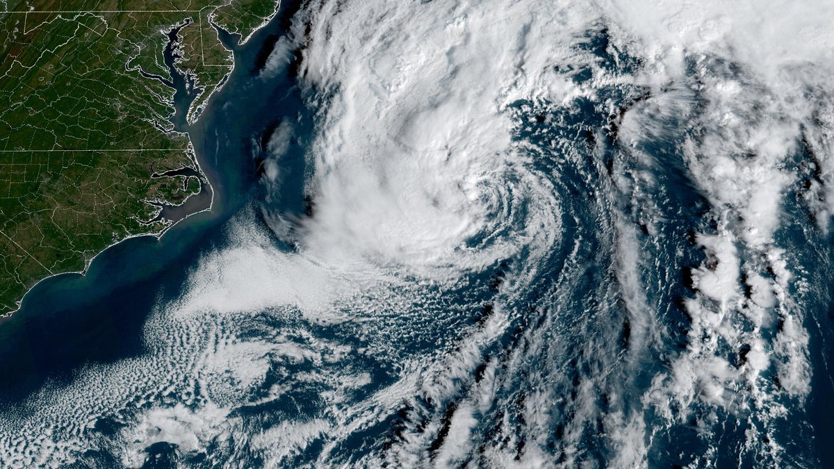
A strong nor'easter is spinning off the Carolina coast and is expected to keep battering the eastern edge of the country with flooding tides, pounding surf and gusty wind for much of the week. The center of the storm should stay over the ocean, so most of its heavy rain will fall at sea. The coastline is still in for a rough few days.
The Outer Banks take the worst of it
North Carolina's barrier islands are again in the bull's-eye. A mandatory evacuation remains in place on Hatteras Island after ocean water washed over the island and stretches of Highway 12 were shut down. Forecasters warned that parts of coastal North Carolina could see 1 to 4 feet of water above normally dry ground, while waves as tall as 14 feet roll in along the beaches.
Gusts near 40 miles per hour are possible on the Outer Banks and could knock down power lines and slow travel. Cape Hatteras could see wind close to 39 miles per hour. Virginia Beach could get gusts in the low 30s.
Tides to watch farther north
From Virginia through Maryland, Delaware and New Jersey the threat is a long string of high tides pushed higher by a steady north-northeast wind. Advisories cover the Jersey Shore and the Delaware beaches, where 1 to 2 feet of flooding is possible in low spots. Weather service forecasters flagged Tuesday evening as the first high tide of concern and said more rounds could follow overnight and on Wednesday.
Water levels in the Chesapeake Bay and at Ocean City, Maryland is expected to climb more than 2 feet above normal. Towns on the Jersey Shore warned residents that streets near tidal creeks and back bays could go under water and that some roads may close at high tide. Wednesday evening's tide looks like the one to watch most closely.
Beach erosion is expected along much of the East Coast. Rough surf and rip currents are forecast from Florida's Atlantic beaches to New England. Cape Cod and Nantucket should get rain and coastal flooding later in the week, with wind near 44 miles per hour possible on Nantucket by Thursday.
Could it get a name?
The National Hurricane Center is tracking the system as Invest 93L. It gave the storm about a 40% chance of turning into a tropical or subtropical system. If that happens it would be named Josephine. Forecasters stressed that the name would not change much. Any strengthening would come as the storm moves east and away from land. The effects on the coast would be the same either way.
A cold front is expected to scoop the storm up and carry it out to sea late Thursday into Friday, which should finally calm the coast. This storm is not expected to be as strong as the nor'easter that struck in late September.
Rain and snow in the West
A separate storm from the Pacific is aiming heavy rain at the other side of the country. Flash flooding is possible from Southern California to the Rockies through Thursday, from San Luis Obispo to Santa Barbara and across the Four Corners states. About 6 million people in Arizona, including Phoenix and Flagstaff, are under a flood watch. Higher mountains could see snow.
Officials on both coasts urged people to obey red flags at the beach, stay out of the surf when waves look large and never drive through water covering a road.
More like this

Nor'easter takes aim at the Outer Banks as Hatteras Island visitors are ordered to leave
Tropical Storm Rachel leaves Long Beach homes unsafe and sets a Las Vegas rain record

Two years after Helene, western North Carolina mountain towns are still digging out

Freeze warnings hit the Upper Midwest and Plains as a strong cold front sweeps east